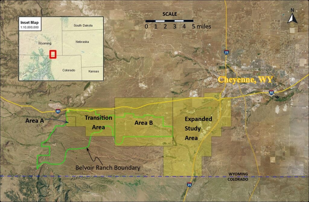
Atlas D Missile Site 4 (Atlas Site 4) located in Laramie County, Wyoming is a Formerly Used Defense Site (FUDS), previously under the command of F.E. Warren Air Force Base (AFB). The U.S. Army Corps of Engineers (USACE), Omaha District, is managing the environmental cleanup in response to former activities at the site that have contaminated the groundwater with trichloroethene (TCE), a cleaning solvent. The former missile site is located approximately 18 miles west of Cheyenne and one mile south of the town of Granite, Wyoming. The site vicinity is illustrated in Figure 1 below; the former missile site is located in Area A. The groundwater flow direction is to the east from Area A.
The property was one of four Atlas D missile sites and nine Atlas E missile sites operated in Colorado, Nebraska, and Wyoming by F.E. Warren AFB. The Atlas D model was the first fully operational strategic missile developed by the U.S. and, with a range of 8,700 miles, was designed for deployment of high-yield nuclear warheads against the Soviet Union. The Atlas D missile used liquid rocket propellant-1 (RP-1, similar to kerosene) for fuel and liquid oxygen as the oxidizer.
Atlas Site 4 utilized three Launch and Service Buildings (LSBs) located in Area A for the housing, readiness, and potential launch of nuclear missiles. During readiness exercises conducted at each of the three LSBs, the RP-1 was pumped from an underground tank into the missiles and then pumped back into the tank. TCE was used as a solvent to clean the rocket fuel tanks, engines, and liquid oxygen lines, and, since TCE is non-flammable, to prevent accidental explosions. Spent TCE and other wastes generated during the readiness exercises drained into long unlined pits 15 to 20 feet deep (referred to as Flame Pits). A site map for the Atlas Site 4 LSB Area showing key site features is provided as Figure 2 Missile Site LSB Area Map. Under the assumption that all three LSBs were tested each of the three years of operation, the estimated total amount of TCE that may have been released to the subsurface by disposal in the flame pits would range from 450 to 16,200 gallons.
Atlas D Missile Site 4 originally consisted of approximately 703 acres acquired by the USA in the late 1950s and developed between 1959 and 1962. By 1964, the liquid-fuel Atlas D missiles were being phased out in favor of new solid-fuel Minuteman Intercontinental Ballistic Missiles. By 1976 the abandoned missile site had been incorporated into the much larger Belvoir Ranch. The Belvoir Ranch was acquired by the City of Cheyenne and the Cheyenne Board of Public Utilities in 2003 and currently encompasses nearly 20,000 acres. The ranch has a stock watering system that supports seasonal cattle grazing and is also leased by an electricity generation company that operates 88 wind turbines on the ranch.
The former missile site and the downgradient Belvoir Ranch and adjoining properties comprise the Atlas Site 4 groundwater contamination project site, which has been partitioned into four general areas based on site characteristics and project objectives. The four general areas for Atlas Site 4 are defined as Area A, the Transition Area, Area B, and Expanded Study Area as shown in Figure 1 above. Figures 3, 4, and 5 illustrate Area A, (pdf link) the Transition Area, (pdf link) and Area B (pdf link).
Area A includes the Atlas Site 4 LSB area (the contaminant source area), located in Section 20, Township 13 North, Range 69 West [6th Principal Meridian]. Numerous monitoring wells have been installed in this area by USACE, including 18 triple-nested monitoring wells. TCE has been detected on-site at the LSB area (located in Area A) at a maximum level of 200,000 micrograms per liter (ug/L) in samples collected from one monitoring well located in the flame pit at LSB #1. Along the east edge (downgradient edge) of the LSB area TCE concentrations in groundwater samples range between 300 and 4,000 ug/L. The TCE plume extends 11 miles east (i.e., downgradient) from the LSB area. Five miles east of the source area (at the east end of the Transition Area), TCE concentrations in groundwater samples collected from monitoring wells located within the TCE plume are generally less than 40 ug/L. The U.S. EPA maximum contaminant level (MCL) for TCE in drinking water is 5 ug/L, equal to 5 parts per billion (ppb).
The Transition Area extends mostly east from Area A and covers 12 square miles of the Belvoir Ranch, including two square mile sections located north and northeast of Area A. The Transition Area includes a five-mile segment of Lone tree Creek, of which only a couple miles have perennial flow, with the creek bed dry most of the year in the east part of the Transition Area. Several monitoring wells have been installed in this area by USACE. Two stock wells used by the ranch are located in the northwest corner, 1/2 mile north of the LSB area/Area A. The groundwater TCE plume is about 1/2 mile wide as it extends through the Transition Area, with concentrations decreasing to approximately 40 ug/L (ppb) at the east end.
Area B is a 30-square-mile portion of Atlas Site 4 extending east from the Transition Area for five miles. Area B encompasses approximately 80 percent of the Borie Well Field, where the shallow aquifer (High Plains Aquifer) is used extensively for agricultural and industrial purposes, as well as a municipal water source for the City of Cheyenne and drinking water for several residential wells. Several deep oil wells are also located in the northeastern part of Area B.
- Atlas D Missile Site 4 Fact Sheet, Spring 2021
- Atlas D Missile Site 4 Fact Sheet, Fall 2020
- Atlas D Missile Site 4 Fact Sheet, Summer 2019
- Atlas D Missile Site 4 Fact Sheet, Fall 2018
- Atlas D Missile Site 4 Fact Sheet, Spring 2018
- Atlas D Missile Site 4 Fact Sheet, Fall 2017
- Atlas D Missile Site 4 Fact Sheet, Winter 2016
- Atlas D Missile Site 4 Fact Sheet, Autumn 2015
- Atlas D Missile Site 4 Fact Sheet, Summer 2015
- Atlas D Missile Site 4 Fact Sheet, Spring 2015
- Atlas D Missile Site 4 Fact Sheet, Winter 2015
- Atlas D Missile Site 4 Fact Sheet, Summer 2014
- Atlas D Missile Site 4 Fact Sheet, Fall 2013
- Atlas D Missile Site 4 Fact Sheet, Spring 2013
- Atlas D Missile Site 4 Fact Sheet, Fall 2012
- Atlas D Missile Site 4 Fact Sheet, Fall 2010
- Atlas D Missile Site 4 Fact Sheet, Summer 2010
- Atlas D Missile Site 4 Fact Sheet, Winter 2010
- Atlas D Missile Site 4 Fact Sheet, Summer 2009